Sensation Map Generator
Process and Logic Flows
Transcribe Map into Shapefiles
graph TD
TM1[Use a georeferenced tif of a map.] --> TM2[In QGIS, create a new project. Add the map tif as a raster layer.]
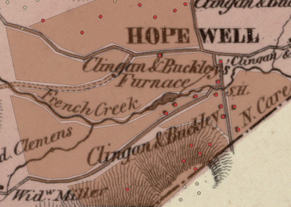
TM2 --> TM3[Add shapefile of charcoal hearths as a vector layer.]
TM3 --> TM4["To store points on the map such as
buildings and charcoal hearths,
create a new shapefile Layer.
file name: hopewell_selected_elements
geometry: Points
crs:EPSG:4326
Added fields
type (string length 40)
name (string length 80)
desc (string length 254)
"]
TM4 --> TM5[Added points for buildings and charcoal hearths.]
TM5 --> TM6["To store polygons to represent the landscape such as
forest, field, creek, road, path,
create a new shapefile Layer.
file name: hopewell_selected_elements_polys
geometry: Polygons
crs:EPSG:4326
Added fields
type (string length 40)
name (string length 80)
desc (string length 254)
"]
TM6 --> TM7[Added polygons for landscape.]
TM7 --> TM8["Copied shapefiles to Google Drive. (Later, via Github)."]
QGIS map transcription:
Transfer map coordinates to user's location and generate new map.
graph TD
TMCU1["In Notebook sensory_map_generator.ipynb
Section: 1. Package installation Mount Google Drive"] --> TMCU2["Mount Google Drive
Install packages"]
TMCU2-->TMCU3["Section: 2. Relocate map coordinates to get ready to unroll map at your location's latitude longitude"]
TMCU3-->TMCU4["Set user location, latitude and longitude.
example:
local_lat = 45.475871
local_lon = -75.549315"]
TMCU4-->TMCU5["The original map has a reference point
that other points on the map have a bearing and distance to.
Example: (40.20595294149071, -75.77220799054444)"]
TMCU5-->TMCU6["The generated local map's reference point is
(local_lat, local_lon) set above"]
TMCU6-->TMCU7["For each point and each vertex in a polygon."]
TMCU7-->TMCU8["Use the function transition_point to:
Get the point's distance and bearing from the original map reference point.
using geod = Geodesic.WGS84.Inverse()
"]
TMCU8-->TMCU9["Calculate the point on the new map:
Use the distance and bearing from the new map's origin point.
new_map_point = VincentyDistance(meters=distance).destination(origin, bearing)
"]
TMCU9-->TMCU10["Save the new points and polygons in shapefiles"]
TMCU10-->TMCU11["Print the Python code to call the GenerateLeafletMap class
to create markers for each point as well as polygons."]
TMCU11-->TMCU12["Plot the shapefiles on a basemap to check if the map is plotter where the user would like."]
TMCU12-->TMCU13{"Is map in
desired location"}
TMCU13-->|No| TMCU13N["Reposition user location."]
TMCU13N-->TMCU4
TMCU13-->|Yes| TMCU13Y["Generate map using the next section."]
TMCU13Y-->GM1["In section 3. Generate the map to display at your location"] --> GM2["Copy and paste the Python code printed in the cell above.
This code calls the GenerateLeafletMap class
to create markers for each point as well as polygons."]
GM2-->TMCU11
GM2-->GM3["Run the cell to generate /sensation/userloc.html."]
GM3-->GM4["In section 4. Test generated map using http server on Google Colab
Test the map.
Start the http server.
Click on the link."]
GM4-->GM5{"Is map
correct?"}
GM5-->|Yes|GM5Y["Place files on http server accessible to a smart phone.
userloc.html - It must be accessible using https://
Copy files in /icons and /sounds to website.
"]
GM5-->|No|GM5N["Correct errors, make improvements."]
GM5N-->GM1
Program logic
graph TD
PL1["In userloc.html Javascript."] --> PL2["Position all static markers
Use ? icon."]
PL2-->PL3["Position all polygons
fillOpacity: 0."]
PL3-->PL4["Position a draggable test marker with a computer icon."]
PL4-->PL5["Position a marker for the user's location. Update every 3 seconds."]
PL5-->PL6{"Is user's location
or test marker
within .1 km of a marker?"}
PL6-->|No|PL5
PL6-->|Yes|PL7["Reveal marker.
Update popup text.
Add a link to an audio file.
Change icon."]
PL7-->PL8{"Is user's location
or test marker
within .1 km of a polygon?"}
PL8-->|No|PL5
PL8-->|Yes|PL9["Reveal polygon for landscape.
Update popup text.
Add a link to an audio file.
fillOpacity: 0.7"]
PL9-->PL5